Part of a larger reconstruction effort by Infonavit following the 2017 earthquakes in Jojutla de Juárez, a municipality located in the south of the state of Morelos, Mexico, OMA New York has designed a new pedestrian bridge connecting the eastern zone and downtown Jojutla, which had suffered structural and environmental damage.
Running north-south and dividing Jojutla’s urban center, the Apatlaco River was among the most affected areas. The earthquake of September 19, 2017 revealed the brittle infrastructure of the city and its relationship to the Apatlaco river—houses built on edges of the river collapsed due to weakened structure; the major drainage line of the city running over the river suffered persistent fractures and its segments destroyed; open spaces, that would otherwise serve as open public parks and amenities, were left behind and taken overcome with landfill; and preexisting lack of access to cross the river was exacerbated by the destruction of a main bridge, severing mobility. The absence of intervention along the river edges leave the surrounding neighborhoods vulnerable to flooding.
In 2018, OMA New York designed a bridge to facilitate a much-needed link between currently disconnected communities, create a new commercial axis, and transform the riverbank into a rehabilitated zone of activities in an effort to transform the Apatlaco River into a community resources rather than a threat.
A linear bridge is bent into a shape—dodging private properties, crossing the river twice, and anchoring itself to three distinct points of the city: Panchimalco, a colony south of the municipal capital; the blocks at the bottom of Pacheco alley, in close proximity to the historic center; and the Juarez neighborhood, the most central but most damaged by the earthquake.
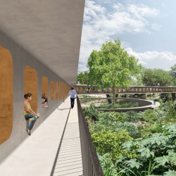
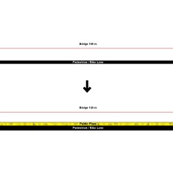
Its form is akin to a large I-beam, giving way to a double-decker concrete structure. Its upper deck simultaneously provides a higher datum in anticipation of water level rise and shade for the dedicated pedestrian and bicycle paths below. The “flanges” allow for a wide surface for occupiable spaces in addition to mobility. Along the entire length of the bridge, the I-beam’s “web” is perforated. Its habitable openings of various scale operate as undefined spaces, benches, stairs, and doors accommodate a diversity of activities, pace, and access. Windows open up the bridge to its surroundings and frame the landscape around it. Unobstructed, the upper deck provides opportunity to incorporate a linear park, plaza, and market to encourage a new commercial axis as a connector of disparate communities.
_


