Estudio ACTA . photos: © Fernando Alda
The project stems from the consideration that the citizens of the 21st century no longer live in confined places – even if they live in them – with hardly any relationship with the neighbours of other nearby municipalities. The concept of Territory, as a space where life takes place – work, residence, leisure, social relations – calls for the establishment of links between the different parts that make up our physical reality, beyond the creation of new administrative entities.
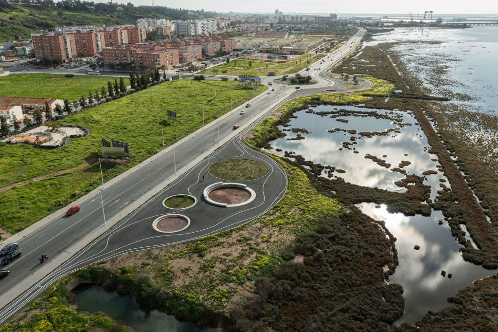
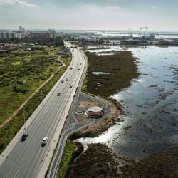
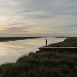
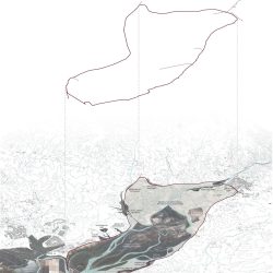
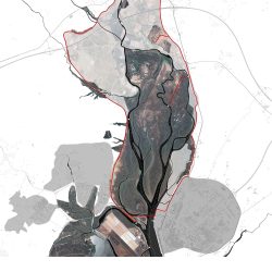
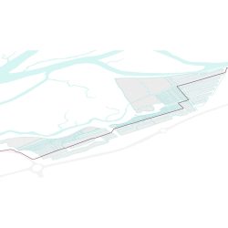
This is a great green infrastructure of a supra-municipal nature, 30 km long, which connects the towns of Huelva, Aljaraque and Gibraleón – with a total of 180,000 inhabitants – and brings them closer to the great environmental, scenic, botanical, zoological and heritage wealth that encompasses the vast protected natural area of Marismas del Odiel that surrounds them (7,200 hectares). The main objectives are non-motorised accessibility between the three towns mentioned above by means of a multimodal road along the edge of the northern estuary of the Odiel; and the requalification of the degraded urban-rural edges by means of environmental regeneration and improvement of their landscape image.
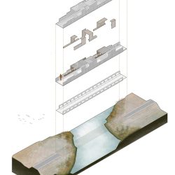
The intervention is voluntarily contaminated by other disciplines beyond the purely architectural, already present in the work territory. And so, in addition to architecture, it is also engineering (bridges), hydraulics (floodgates and sheet piling), infrastructure (roads and breakwaters), landscape (viewpoints), heritage (Tharsis wharf-loader), ethnography (tidal mills and salt marshes), botany (25,000 new specimens planted), biology (sheets of water for bird roosting), sport (piers for canoeing and fishing) and even public health (promotion of non-motorised mobility).
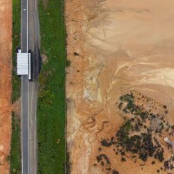
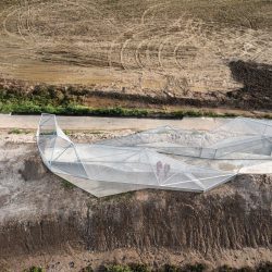
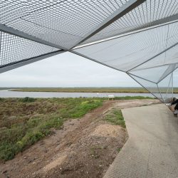
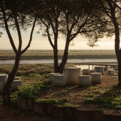
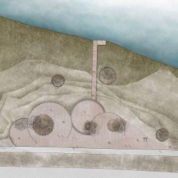
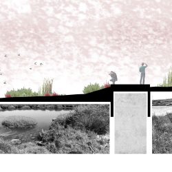
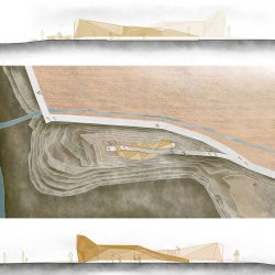
The route runs along disused railways, livestock trails, marsh edges, abandoned salt marshes, and the occasional urban section. Just as any text needs punctuation marks to be legible, the itinerary is punctuated by a series of elements (pergolas, bridges, jetties, rest areas, viewpoints or rooms) which, as strategically located architectural-sculptural proposals of territorial acupuncture, help to mark out the route, mark the rhythms and make the territory legible.
The project continually swings between the large scale of the territory in which it operates and of the intervention itself (XXL) and the small scale of the architectural pieces built (XXS), with hardly any of the usual scale or average dimensions in architecture. Likewise, the meagre budget managed for an intervention of this calibre has forced us to sharpen our ingenuity and concentrate our efforts on very specific points of the extensive route.
To define its morphology and choose the materials used to define it, the strategy was to remember the rich natural and cultural heritage of the territory and maintain its essence: the riverside, mining and railway character, and its conception as a great scenic viewpoint from the rural land. All of this is expressed in the use of curved, natural, sinuous and organic shapes, the same shapes that the intertidal nature shows us. In terms of materials, we have resorted to those used historically in this territory: breakwaters, mud walls, floodgates, sheet piles, eucalyptus poles, untreated wood that blends in with the environment, and water crossings reinterpreted with honeycomb panels. The traces of the rich mining-railway past are reflected in the use of steel and perforated sheet metal used to build bridges, pergolas and belvederes, hybrids of architecture and sculptures stranded in the territory.
In short, starting from an infrastructure and communications project, we propose to give added value to the intervention, until it becomes an equipped park. In short, it is a question of taking advantage of a 30 km. loop operation to reflect on the future and the development of the territory it envelops.
_


La actuación nace de la consideración de que los ciudadanos del siglo XXI ya no habitan en lugares confinados -aunque residan en ellos-, sin apenas relación con los vecinos de otros municipios cercanos. El concepto de Territorio, como espacio donde se desarrolla la vida –trabajo, residencia, ocio, relación social- reclama el establecimiento de lazos entre las distintas partes que componen nuestra realidad física, más allá de la creación de nuevos entes administrativos.
Estamos ante una gran infraestructura verde de carácter supramunicipal, de 30 km. de longitud, que conecta las poblaciones de Huelva, Aljaraque y Gibraleón –con unos 180.000 habitantes en total- y los acerca a la gran riqueza medioambiental, paisajística, botánica, zoológica y patrimonial que engloba el vasto espacio natural protegido de Marismas del Odiel que les rodea (7.200 Has.). Como objetivos principales, la accesibilidad no motorizada entre las tres poblaciones mencionadas mediante una vía multimodal que recorre el borde del estuario Norte del Odiel; y la recualificación de los bordes urbano-rurales degradados, mediante la regeneración ambiental y mejora de su imagen paisajística.
La intervención se contamina voluntariamente de otras disciplinas más allá de la puramente arquitectónica, ya presentes en el territorio de trabajo. Y así, además de arquitectura es ingeniería (puentes), hidráulica (compuertas y tablestacas), infraestructura (caminos y escolleras), paisaje (miradores), patrimonio (muelle-cargadero de Tharsis), etnografía (molinos de mareas y salinas), botánica (25000 ejemplares nuevos plantados), biología (láminas de agua para estancias de aves), deporte (embarcaderos para piraguas y pesca) y hasta salud pública (fomento de la movilidad no motorizada).
El recorrido discurre por vías férreas en desuso, vías pecuarias, bordes de marismas, antiguas salinas abandonadas, y algún que otro tramo urbano. Al igual que cualquier texto necesita los signos de puntuación para ser legible, el itinerario se jalona de una serie de elementos (Pérgolas, puentes, embarcaderos, áreas de descanso, miradores o estancias) que, a modo de propuestas arquitectónico-escultóricas de acupuntura territorial y estratégicamente situadas, contribuyen a pautar el recorrido, marcar los ritmos y hacer legible el territorio.
El proyecto bascula continuamente entre la gran escala del territorio donde se actúa y de la intervención propiamente dicha (XXL) y la escala menuda de las piezas arquitectónicas construídas (XXS), no apareciendo apenas ni la escala ni las dimensiones medias habituales en arquitectura. Asimismo, el exiguo presupuesto manejado para una intervención de este calibre, ha obligado a agudizar el ingenio y concentrar los esfuerzos en puntos muy concretos del amplio recorrido.
Para definir su morfología y elegir los materiales con que se define, la estrategia pasa por recordar el rico patrimonio natural y cultural del territorio y mantener sus esencias: el carácter ribereño, minero y ferroviario, y su concepción de gran mirador escénico desde el suelo rural. Todo ello se concreta en el uso de formas curvas, naturales, sinuosas y orgánicas, las mismas que la naturaleza intermareal nos muestra. En cuanto a materiales, hemos recurrido a los usados históricamente en este territorio: escolleras, muros de fango, compuertas, tablestacas, hincado de palos de eucalipto, maderas sin tratar que empastan con el ambiente, y pasos de agua reinterpretados con placas alveolares. Las huellas del rico pasado minero-ferroviario tienen su traslación en el empleo del acero y la chapa perforada con que se construyen puente, pérgolas o mirador, híbridos entre arquitecturas y esculturas varadas en el territorio.
En resumen, partiendo de un proyecto de infraestructura y comunicaciones, proponemos dar un valor añadido a la intervención, hasta convertirla en un parque equipado. En definitiva, se trata de aprovechar una operación de 30 km. de recorrido en bucle, para reflexionar sobre el futuro y el desarrollo del territorio que envuelve.