Carles Enrich Studio . photos: © Adrià Goula
Rec Comtal has been one of the most important hydraulic infrastructures in Barcelona that supplied water and irrigated the Besos agricultural territory from the 10th century to the middle of the 20th century.
Being an open-air ditch, during its active period, it meant a catalyst for public space and the social life of citizens and an exploitation of agriculture and industry. Therefore, it is an essential element to understand the economic and social development of the last thousand years in Barcelona.
Nowadays, almost all Rec Comtal has disappeared due to urban growth in the last century and the archaeological remains are abandoned. The only section that maintains running water is located in the Vallbona neighborhood, although it only accounts for 5% of the total 14.56 km of the Rec.
As the first pilot intervention within the framework of the Master Plan for the recovery of the Rec Comtal, an intervention of renaturation and environmental restoration of its surroundings is carried out in two points of the Vallbona neighborhood. Both presented a degradation and an abandonment process turning the Rec Comtal into a residual space in danger of disappearing. To value this historical element and recover the condition of green infrastructure, a plantation of riverside vegetation and macrophyte species is proposed. This improves the quality of the water (Fraxinus Angustifolia, Salix atrocinerea, Vinca difformis, Vitex agnus-castus, Iris pseudacorus, Carex pendula, Scirpus holoschoenus, Juncus acutus…), generates more shade to cool the river temperature and promotes a suitable habitat. for those new species of fish, birds, and amphibians that recover.
The recovery of biodiversity requires the planting of plant species that attract their associated fauna and guarantee the biological cycles of growth, dispersion, and recycling of these biomes, trying to make them as autonomous as possible.
The proposed interventions serve to improve the quality of surface water and aquifers, reduce the negative effects of rainfall, increase drainage and soil quality, regulate urban microclimates and generate climatic shelters, improve local ecosystems, and many more actions. management that can contribute to improving the lives of citizens. This renaturation generates a green corridor along the Rec Comtal.
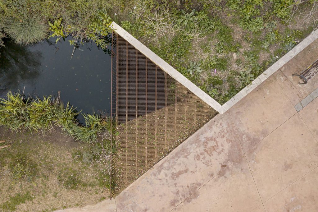
On the other hand, two light structures are built, configured with corrugated profiles supported on pre-existing elements such as sewer pipes or retaining walls, which allow an approach to the water while improving safety against falls. At the same time, the new biodiversity viewpoints act as landscape elements that will be extended to other points of the Rec Comtal route.
_
Master Plan for the recovery of Rec Comtal. Urban Planning
Architect: Carles Enrich Studio
Collaborators: Marta Fàbregas (archeology), Santi Riera (bioarcheology), Aiguasol (energy), Cíclica (urban ecology), Legal Barcelona (legality), Wassabi Produccions (multimedia)
Client: Barcelona City Council
Surface area: 14.557 km
El Rec Comtal es una de las infraestructuras hidráulicas más importantes de Barcelona que abastecía de agua la ciudad e irrigaba el territorio de la cuenca agrícola del Besós desde el siglo X hasta la mitad del siglo XX.
Al tratarse de una acequia al aire libre, durante su período activo, significó un catalizador del espacio público y de la vida social de los ciudadanos y una explotación de la agricultura y la industria. Por este motivo se trata de un elemento indispensable para entender el desarrollo económico y social de los últimos mil años de la historia del plan de Barcelona.
Actualmente buena parte del Rec Comtal ha desaparecido debido al crecimiento urbano de los últimos años. El carácter y actividad vinculada al Rec se han perdido y los restos arqueológicos que se conservan se encuentran en estado de abandono. El único tramo que mantiene agua corriente se encuentra en el barrio de Vallbona aunque sólo supone un 5% de los 14,56 km totales del Rec.
Como primeras intervenciones piloto dentro del marco del Plan Director para la recuperación del Rec Comtal se realiza una intervención de renaturalización y restauración ambiental de su entorno en dos puntos del barrio de Vallbona. Ambos presentaban una degradación y un proceso de abandono convirtiendo el Rec Comtal en un espacio residual en peligro de desaparición. Para poner en valor este elemento histórico y recuperar la condición de infraestructura verde se plantea una plantación de vegetación de ribera y especies macrófitas. Ésta mejora la calidad del agua (Fraxinus Angustifolia, Salix atrocinerea, Vinca difformis, Vitex agnus-castus, Iris pseudacorus, Carex pendula, Scirpus holoschoenus, Juncus acutus...), genera más sombra para enfriar la temperatura fluvial y potencia un hábitat adecuado para aquellas nuevas especies de peces, pájaros y anfibios que se recuperan.
La restauración de la biodiversidad requiere la plantación de especies vegetales que atraen a su fauna asociada y garantizan los ciclos biológicos de crecimiento, dispersión y reciclaje de estos biomas, intentando que sean lo más autónomos posibles.
Las intervenciones propuestas sirven para mejorar la calidad del agua superficial y de los acuíferos, aminorar los efectos negativos de las lluvias, aumentar el drenaje y calidad de los suelos, regular los microclimas urbanos y generar refugios climáticos, mejorar los ecosistemas locales y muchas más acciones de gestión que pueden contribuir a mejorar la vida de los ciudadanos. Esta renaturalización genera un corredor verde a lo largo del Rec Comtal.
Por otra parte, se construyen dos estructuras ligeras, configuradas con perfiles corrugados soportados en elementos preexistentes como tubos de alcantarillado o muros de contención, que permiten una aproximación al agua a la vez que mejoran la seguridad frente a las caídas. Al mismo tiempo, los nuevos miradores de biodiversidad actúan como elementos paisajísticos que tendrán una prolongación en otros puntos del trazado del Rec Comtal.


