office x sara maduro raffaele sarubbo . Sossio De Vita . Giuseppe Parisi . renders: © Riccardo de Vincenzo
The proposal for the archeological complex of the roman villa of Rabaçal, has its starting point rooted in the analysis of the landscape in which it is inserted.
The landscape and architectural project make a synthesis and formalize a set of different factors related to the Rabaçal valley.
In a territory of such a kind, water represents the determining factor both in terms of landscape and haritage, being able to influence the urban and architectural tissue other then the socio-economical system. As a result, in the reading and understanding of the landscape the Mondego river and its tributaries play a fundamental role representing the strongest elements of continuity.
As well as the new archaeological arrangement, the Roman pre-existencies find their composition and reason of being in the presence of water. The ancient villa used to have an octagonal water basin. The small thermal bath took the water from the nearby tributary to be heated. The farm had the possibility to raise a variety of animals and cultivate an extensive agricultural territory thanks to the presence of water.
The intervention focuses on the realization of a core that assumes the role of a reference element for a set of projects and networks able to structure the landscape system of the Lower Mondego on different scales.
Considering as a starting point the importance of water as a structural element of the territory, the proposal interacts with the existing waterlines designing a park that integrates the archeological complex and guides the route so as to create points of interest in the areas of contact between built elements and existing landscape elements.
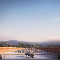
The museum is designed as an enclosing fence that delimits and protects the archeological remains, creating in such a way a time suspension.
The proposal for the museum circuit is based on the reading of the landscape as an en plain aire museum, and the museum as a path extending into the landscape, enriched by the relationships between the interior and the exterior of the enclosure.
The roofings protecting the archeological ruins, supported by slender steel pillars, develop at a greater height than that of the building/fence, so as not to interfere with the sight of archaeological excavations.
The visit of the archaeological area is marked by the relationship that the visitor establishes with the olive grove raising on the perimeter of to the excavations, along which the trunks and columns of the roof merge into a single covering.
The roofing, recalling the free and incomplete shape of the excavation area, collects rainwater. The effect of this floating roofs is once again related to water. Its materiality in wood and steel further strengthens the idea of lightness and flexibility over time.
The roof surface, in this case the most important “facade”, requires special attention. This curved surface collects rainwater creating a body of water perceivable from the highest view points of the surrounding landscape and operating as a water cistern for the excavation area.
_


Archaeological Museum for the Roman Villa in Rabaçal, Portugal – 1° prize
office x sara maduro raffaele sarubbo
Sossio De Vita
Giuseppe Parisi
Collaborators:
Francesca Crotti, Turan Ziaiemehr
Images:
Riccardo de Vincenzo
Location:
Rabaçal, Portugal
Dimensional info:
Surface Area: 204 873,50m2
Surface New Museum: 1934,55m2
Surface New enclosure: 29 882,50m2
Parking area: 78 cars, 3 bus
Protection of Archaeological ruins: 3 238, 50 m2
Cost: 5 580 000 €
·
La proposta per il complesso archeologico della Villa Romana di Rabaçal, definisce come punto di partenza l'analisi del territorio in cui si inserisce il nucleo.
Il progetto architettonico e paesaggistico formalizza e sintetizza un insieme di fattori che si relazionano con la  Valle di Rabaçal.
In un territorio in cui l'acqua si presenta come fattore determinante in termini paesaggistici e storici, capace di influenzare le forme di occupazione urbanistiche e architettoniche oltre che sociali ed economici, risulta di rilievo una lettura del paesaggio che considera il fiume Mondego e i suoi affluenti come elementi di continuità territoriali.

Le preesistenze romane trovano, come il nuovo progetto di sistemazione archeologica, la loro ragione d’essere e compositiva nella presenza dell’acqua. La villa aveva un bacino d’acqua a base ottagonale. La piccola terma prendeva l’acqua dal vicino affluente per essere riscaldata. La fattoria aveva la possibilità di allevare una moltitudine di animali e coltivare un esteso territorio agrario grazie alla presenza dell’acqua.
Il progetto si concentra nella realizzazione di un nucleo che assume il ruolo di elemento di riferimento per un insieme di progetti e reti in grado di strutturare il sistema paesaggistico del Basso Mondego su diverse scale.
Considerando come punto di partenza l'importanza dell'acqua in quanto elemento strutturante del territorio, la proposta si relazione con le linee d'acqua esistenti nel concepire un Parco che integri il complesso archeologico e guidi la percorrenza creando punti d'interesse nelle aree di contatto tra elementi costruiti e elementi paesaggistici esistenti.
Il Museo è disegnato come un recinto che delimita e protegge le vestigia archeologiche in una strategia di sospensione del tempo storico.
La proposta per il percorso museografico si basa nella lettura del “paesaggio come museo" e del “museo come un percorso” che si estende nel paesaggio arricchendosi delle relazioni tra l'interno e l'esterno del recinto.
Le coperture che proteggono le vestigia archeologiche, sorrette da esili pilastri in acciaio,  si sviluppano ad un'altezza superiore a quella dell'edificio/recinto, in modo da non interferire la vista degli scavi archeologici.
La visita dell'area archeologica è segnata dalla relazione che il visitatore instaura com l'uliveto perimetrale agli scavi, nel quale i tronchi e le colonne della copertura si fondono in un unico tetto.
La copertura, riprendendo la forma libera e incompleta dell'area degli scavi, raccoglie l’acqua piovana. L'effetto di questo tetto galleggiante è legata all’acqua, elemento che da epoca remota connota l’area. La sua materialità in legno e acciaio rafforza ulteriormente l’idea di leggerezza e flessibilità nel tempo.
La superficie del tetto, in questo caso la "facciata" più importante, richiede un'attenzione particolare. Questa superficie curva raccoglie l'acqua piovana creando uno specchio d'acqua leggibile dai punti alti del territorio e funzionando da cisterna idrica per la zona degli scavi.